Boating on lakes is a beloved pastime for many, offering the serenity of nature, the thrill of water sports, and the joy of fishing. To enhance this experience, technology has provided us with various tools, and one of the most significant advancements in recent years is the Navionics app. This comprehensive guide will explore the use, benefits, pros and cons, download process, and cost of the Navionics app for lake boating enthusiasts!
What is the Navionics App?
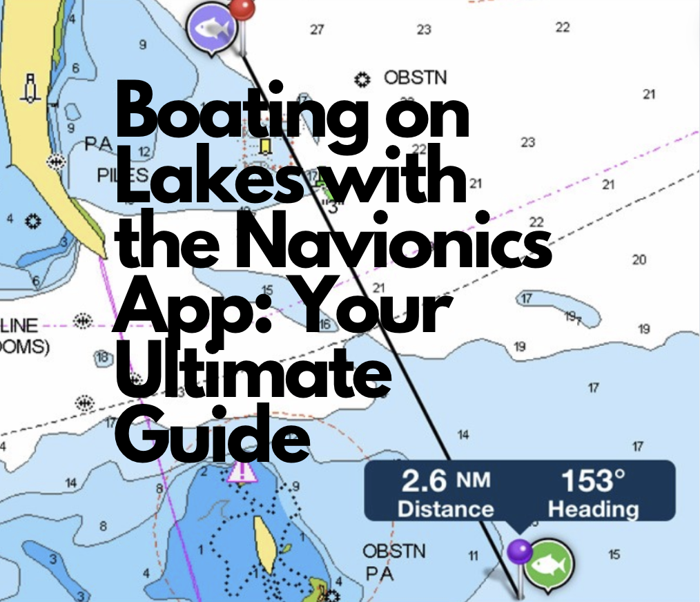
The Navionics app is a powerful tool designed to provide detailed marine and lake charts for boating enthusiasts. Developed by Navionics, a leader in electronic navigation charts, this app offers a range of features that make it easier to navigate and explore lakes, ensuring a safer and more enjoyable boating experience.
Key Features of the Navionics App
Detailed Charts: The app provides highly detailed charts of lakes, including depth contours, underwater structures, and more.
GPS Navigation: Real-time GPS tracking allows you to see your location on the map, helping you navigate the lake with precision.
Route Planning: Plan your routes before heading out, ensuring you hit all your favorite spots and avoid potential hazards.
Community Edits: Access user-generated content such as fishing spots, hazards, and other points of interest shared by the boating community.
Weather and Tides: Stay updated with real-time weather forecasts and tide information, crucial for planning your boating trips.
SonarChart™ Live: Create personal maps in real-time with SonarChart™ Live, which overlays your maps with current sonar data from your boat’s fishfinder.
Auto Guidance+™: This feature suggests the best routes based on your boat’s specifications and navigational data.

Benefits of Using the Navionics App
Enhanced Safety: The detailed charts and GPS navigation help prevent accidents by providing clear information on water depth, underwater hazards, and safe routes.
Improved Navigation: Whether you’re fishing, sailing, or cruising, the app’s route planning and real-time tracking features ensure you never lose your way.
Community Contributions: User-generated content adds a personal touch, with insights from other boaters about the best fishing spots, recent hazards, and more.
Weather Awareness: Real-time weather updates allow you to plan your trips around the best conditions, avoiding unexpected weather changes.
Cost-Effective: Compared to traditional chart plotters and GPS devices, the Navionics app offers a more affordable solution with frequent updates and a plethora of features.
Pros and Cons of the Navionics App
Pros:
- Comprehensive Charting: Offers some of the most detailed and accurate marine charts available.
- User-Friendly Interface: Intuitive design makes it easy to use for boaters of all experience levels.
- Regular Updates: Frequent updates ensure that the data is current and reliable.
- Multi-Device Syncing: Use the app on multiple devices, including smartphones and tablets.
- Offline Use: Download charts for offline use, ensuring access even without an internet connection.
Cons:
- Subscription Costs: While the app itself may be free to download, accessing detailed charts and advanced features requires a subscription.
- Battery Usage: Continuous use of GPS and the app can drain your device’s battery quickly.
- Learning Curve: New users might need some time to learn all the features and functionalities of the app.
- Device Dependence: Requires a reliable smartphone or tablet, which may not be as rugged as dedicated marine electronics.
How to Download and Install the Navionics App
Downloading and installing the Navionics app is straightforward and can be done on both iOS and Android devices. Follow these steps:
Visit the App Store or Google Play Store: Open the app store on your device and search for “Navionics Boating”.
Download the App: Select the Navionics Boating app and tap the download button. The app is free to download.
Create an Account: Once installed, open the app and create a Navionics account or log in if you already have one.
Choose Your Subscription: To access detailed charts and premium features, you will need to purchase a subscription. The app offers various subscription plans based on your needs.
Download Charts: After subscribing, you can download the charts for the lakes you plan to visit. This ensures you have access to detailed maps even when offline.
Cost of the Navionics App
The Navionics app itself is free to download, but to access detailed charts and advanced features, a subscription is necessary. The cost varies depending on the region and the level of detail required. Here’s a general breakdown:
- Annual Subscription: Prices typically range from $15 to $50 per year, depending on the region and coverage area. This subscription includes access to Nautical Chart, SonarChart™, and Community Edits.
- Additional Features: Premium features like Advanced Map Options, Auto Guidance+™, and SonarChart™ Live may be included in higher-tier subscriptions or available as add-ons.
Using the Navionics App on Lakes
Using the Navionics app on lakes is straightforward, thanks to its intuitive interface and comprehensive features. Here’s a step-by-step guide to get you started:
Plan Your Trip: Before heading out, use the app to plan your route. You can mark waypoints, identify hazards, and locate points of interest such as marinas, fishing spots, and picnic areas.
Download Offline Charts: Ensure you have downloaded the necessary charts for offline use, especially if you’ll be boating in areas with poor cellular coverage.
Monitor Weather Conditions: Check the app’s weather forecasts and adjust your plans accordingly to avoid bad weather.
Navigate with GPS: Use the real-time GPS tracking to navigate the lake. The app will display your location on the map, helping you stay on course.
Use SonarChart™ Live: If you have a compatible fishfinder, use SonarChart™ Live to create and update your maps in real-time based on current sonar data.
Share Your Discoveries: Contribute to the community by sharing your own points of interest, such as good fishing spots or new hazards.

Maximizing Your Boating Experience
To get the most out of the Navionics app, consider the following tips:
Regularly Update the App: Ensure you always have the latest version of the app for access to new features and updated charts.
Use a Mount for Your Device: Secure your smartphone or tablet with a mount on your boat for easy viewing and operation.
Carry a Backup: Keep a backup power source, such as a portable charger, to avoid running out of battery during your trip.
Explore Community Edits: Take advantage of the community edits for insider tips and shared experiences from other boaters.
Practice Safe Boating: Always prioritize safety by wearing life jackets, informing someone of your boating plans, and carrying essential safety equipment.
Conclusion
The Navionics app is a game-changer for lake boating enthusiasts, offering detailed charts, real-time GPS navigation, and a wealth of features to enhance your boating experience. While there are some costs and a learning curve involved, the benefits far outweigh the cons, making it an essential tool for anyone who loves spending time on the water. Whether you’re a seasoned boater or a novice, the Navionics app can help you navigate with confidence, explore new areas, and enjoy your time on the lake to the fullest. Download the app today and embark on your next lake adventure with the best navigation tool at your fingertips.
Posted by Scott Freerksen “The Lake Guy”